COVID 19 is providing its own unique challenges, requiring all to stay extra vigilant on changing port call conditions and regulations. If you would like updates for all USA ports, the easiest method for reviewing our daily port updates is by visiting: http://ports.moranshipping.com/default.aspx
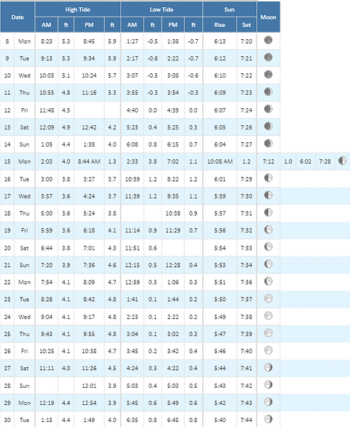
The US Army Corp of Engineers has advised that the current maximum air draft for Cape Cod Canal transits remains at 135 feet. Max draft in the canal is currently 30 feet. Vessels with drafts over 26 feet will need a tide window for transit
Tonight: Mostly cloudy, with a low around 44. West wind 3 to 6 mph.
Tuesday: Mostly sunny, with a high near 65. Light and variable wind becoming east 5 to 7 mph in the morning.
Tuesday Night: Increasing clouds, with a low around 40. Southeast wind 5 to 7 mph.
Wednesday: A chance of showers, mainly after 1pm. Cloudy, with a high near 55. Southeast wind 5 to 10 mph. Chance of precipitation is 40%. New precipitation amounts of less than a tenth of an inch possible.
Wednesday Night: A chance of showers, mainly after 3am. Cloudy, with a low around 45. Northeast wind 5 to 8 mph. Chance of precipitation is 40%.
Thursday: Showers likely, mainly after 5pm. Cloudy, with a high near 57. Northeast wind 6 to 13 mph becoming southeast in the afternoon. Chance of precipitation is 60%.
Thursday Night: Rain. Low around 53. Breezy, with a south wind 15 to 24 mph. Chance of precipitation is 90%.
Friday: Rain, mainly before 3pm. High near 62. Windy, with a south wind around 26 mph, with gusts as high as 38 mph. Chance of precipitation is 100%.
Friday Night: A chance of rain before 8pm. Partly cloudy, with a low around 47. Breezy, with a southwest wind 16 to 20 mph. Chance of precipitation is 30%.
Saturday: Partly sunny, with a high near 57. Breezy, with a west wind 16 to 21 mph, with gusts as high as 31 mph.
Saturday Night: Partly cloudy, with a low around 42. Breezy, with a west wind 17 to 20 mph.
Sunday: Mostly sunny, with a high near 62. West wind around 17 mph.
Sunday Night: Partly cloudy, with a low around 43. West wind 10 to 14 mph.
Monday: Mostly sunny, with a high near 64. West wind 10 to 13 mph.
Tue: N winds around 5 kt, becoming SE in the afternoon. Waves around 2 ft in the morning, then 1 foot or less.
Tue Night: SE winds 5 to 10 kt. Waves around 2 ft.
Wed: SE winds 5 to 10 kt, increasing to 10 to 15 kt in the afternoon. Waves around 2 ft. A chance of showers in the afternoon.
Wed Night: E winds 10 to 15 kt, diminishing to 5 to 10 kt after midnight. Waves around 2 ft. A chance of showers.
Thu: E winds 5 to 10 kt, becoming SE in the afternoon. Waves 2 to 3 ft. A chance of showers.
Thu Night: S winds 15 to 20 kt with gusts up to 25 kt, increasing to 20 to 25 kt with gusts up to 35 kt after midnight. Waves 3 to 5 ft, building to 5 to 7 ft after midnight. Rain.
Fri: S winds 20 to 25 kt with gusts up to 40 kt. Waves 6 to 9 ft. Rain.
Fri Night: SW winds 15 to 20 kt with gusts up to 30 kt. Waves 5 to 7 ft, except 7 to 10 ft at the bay entrance. A chance of rain.
Sat: SW winds around 15 kt with gusts up to 30 kt. Waves 5 to 7 ft.
Sat Night: W winds around 15 kt with gusts up to 25 kt. Waves 4 to 6 ft.
Tonight: SW winds 10 to 15 kt with gusts up to 20 kt, becoming W 5 to 10 kt after midnight. Seas around 2 ft.
Tue: N winds around 5 kt, becoming E in the afternoon. Seas 1 foot or less.
Tue Night: E winds around 10 kt. Seas 1 foot or less.
Wed: SE winds 10 to 15 kt with gusts up to 20 kt. Seas 1 foot or less. A chance of showers in the afternoon.
Wed Night And Thu: SE winds 10 to 15 kt with gusts up to 20 kt. Seas around 2 ft. A chance of showers.
Thu Night: S winds 15 to 20 kt with gusts up to 25 kt, increasing to 20 to 25 kt with gusts up to 35 kt after midnight. Seas 2 to 4 ft, building to 4 to 6 ft after midnight. Rain.
Fri: S winds 25 to 30 kt with gusts up to 40 kt. Seas 6 to 8 ft. Rain.
Fri Night: SW winds 20 to 25 kt with gusts up to 30 kt. Seas 5 to 8 ft. A chance of rain.
Sat: SW winds 15 to 20 kt with gusts up to 30 kt. Seas 4 to 6 ft.
Sat Night: W winds around 15 kt with gusts up to 25 kt. Seas 2 to 4 ft.
Tue: N winds 5 to 10 kt, becoming E in the afternoon. Seas around 2 ft.
Tue Night: SE winds around 10 kt. Seas around 2 ft.
Wed: SE winds 10 to 15 kt with gusts up to 20 kt. Seas around 2 ft. A chance of showers in the afternoon.
Wed Night And Thu: SE winds 10 to 15 kt with gusts up to 20 kt. Seas 2 to 3 ft. A chance of showers.
Thu Night: S winds 15 to 20 kt with gusts up to 25 kt, increasing to 20 to 25 kt with gusts up to 35 kt after midnight. Seas 2 to 4 ft, building to 4 to 6 ft after midnight. Rain. Vsby 1 to 3 nm after midnight.
Fri: S winds 25 to 30 kt with gusts up to 40 kt. Seas 5 to 7 ft. Rain.
Fri Night: SW winds 20 to 25 kt with gusts up to 35 kt. Seas 4 to 6 ft. A chance of rain.
Sat: SW winds 15 to 20 kt with gusts up to 25 kt. Seas 3 to 5 ft.
Sat Night: W winds 15 to 20 kt with gusts up to 25 kt. Seas 2 to 4 ft.
Disclaimer: For quality assurance purposes please note well that while the information contained in this website is regularly vetted for accuracy it is not intended to replace the local knowledge or expertise pertaining to port conditions of our marine operations personnel.
News Bulletin
Sign up to receive updates about port conditions, important notices, and other news.